
|





|

An Explorer's Guide to Whitehorse, Yukon
Dateline: January 6, 2023. Last update: May 14, 2024.
There are 151 events, and 27 photos/graphics.
One of the two access roads from the Alaska Highway to downtown Whitehorse was built over the winter of 1962-1963. It was originally just called the South Access, and despite being named Robert Service Way in 1995, it remains the South Access for many people.
The highlights of the road's history that follow are largely as recorded on the pages of The Whitehorse Star until they ceased publishing on May 17, 2024. The original photos that start in 1990 were shot by Murray Lundberg.
Robert Service Way, July 2, 2022 (Google Earth). Click on the photo to open an interactive map in a new window.

Some highlights in history of Robert Service Way
The first aerial photo, shot in 1961, shows that there was no public road to the Alaska Highway from the south end of Whitehorse. Towards the left of the photo you can see roads joining gravel pits, and some locals report using them, getting into Riverdale by driving across the dam. In an article in The Star on February 28, 2020, Gregory Bryce said that the walking trail to Ear Lake was urgently transformed into the South Access Road in 1958 to provide a second evacuation route from downtown when the huge Takhini Valley forest fire threatened the city.

- August 6, 1962: "Future seat of government was suggested for the area south of Elliott and east of Second. This would include the RCMP, moving the police from their present quarters to provide more residential property in that section. Second Avenue would
be extended along the east side of the railway tracks, joining the south access route to town at that end of the city. Along the riverbank they foresaw a planted area for park use."
- August 23, 1962: "City Council probably will undertake some winter works projects here in the valid period between October 15 and April 30 during which the federal government will pay half the direct payroll costs of men not normally employed. Some of the projects given brief consideration were stabilizing the dump ground dumping area,
filling east of the rail line at the south end of town so the south civic access road could be utilized without crossing the tracks thereby leading straight into Second as envisaged by the CMHC planners; working on the city campground near the hydro dam; community clean up of old junk."
- January 7, 1963: Included in a long list of winter works projects going on were "two new streets with sewer and water in Riverdale; road to hospital paved; five miles of road to Chadburn Lake constructed; gravel work completed on south access road to Alaska Highway." The 1963 aerial photo below shows what the new road looked like that summer.

The next 1963 aerial photo below shows the unauthorized crossing of the White Pass railway tracks at the upper left, and the haphazard connections to 5th and 4th Avenues. To the lower right is the Whisky Flats squatters village, now split by the approach to the Robert Campbell Bridge into Riverdale.

- May 14, 1964: Tenders are called for the installation of guard rails (called guide rails then) along the South Access Road.
- August 10, 1964: An editorial recommends moving the tourist information office from the traffic circle at the top of Two Mile Hill to Robert Service Campground. "The coffee shop crowd has noted the gradual change in the traffic pattern into the city. More northbound travellers are taking the south access into Whitehorse and fewer are coming into town down the Two-Mile Hill.
"Many reasons can be attributed to this move but the two major ones are: erecting a big sign on the roadside by the chamber of cpmmerce south of the south access turnoff and a rounded corner well-signed taking the driver off the Alaska Highway onto
the access route.
"Last year, for instance, few visitors to the city came into town by the south access. They didn't know it existed, Now they do and they come bounding into the city arriving on Main Street before they quite know what has hit them.
"The chamber of commerce sign shows the Whitehorse loop and indicates where the new Robert Service Park campground is located. It doesn't show much more. It's not supposed to. But wouldn't it be convenient for the tourist to have a visitor information building located beside the sign? He could stop and obtain information before coming into the city. He wouldn't have that lost appearance about him when he hits town.
"The tourists who do drive north to the traffic circle and stop in at the tourist information office up there, that's a different story. They are given phamphlew and information about what to see in the city. They also are told about the downtown tourist office in the White Pass building. For our money, this "hill" bureau should be moved south, down where the Robert Service Park sign is. That's where we can catch more visitors and encourage them to drop into Whitehorse."
- August 20, 1964: In the first serious accident on the new road, Gordon R. Scott hit loose gravel near the bottom of the curve and his car overturned in the ditch. He got a sore arm but the car received about $400 in damage.
- November 26, 1964: The Metropolitan Planning Committee agreed with the recommendation that the south access road into the townsite be continued south of the railway line to meet Second Avenue and the approach to the Robert Campbell Bridge.
- May 20, 1965: Tenders are again called for the installation of guard rails along the South Access Road. This time, Malamute Construction was awarded the contract, for $7,659.
- July 22, 1965: City Constable Al Adams recommended to Council that a traffic sign be erected at the entrance to the City at the South access road with directions to city centre and posting of the speed limit on city streets. Council agreed.
- April 18, 1966: Tenders are called for the reconstruction of the South Access Road.
- July 14, 1966: Whitehorse citizens are used to seeing almost anything passing through the Territory during the summer months, but Tuesday night they were making
visits to the South Access Road to see something special. Four hundred and fifty sheep were eating hay and drinking water beside the road. They were on their way from Montana to the John C. Miller sheep ranch in Soldotna, Alaska. The ranch normally flies sheep up and this was an experiment that wasn't going well. The sheep are in pretty rough shape - the road is too bumpy and dusty for them.
- August 15, 1966: A General Enterprises cement mixer truck, loaded with cement, rolled on the South Access Road at 3.25 p.m. Wednesday. Driven by Ross Dehart, the truck was passing a grader and hit a soft shoulder, and rolled over into the ditch.
- August 29, 1966: The South Access saw its first high-speed police chase when Alphonse Berkner ran from police through town, across the bridge and the hydro dam, up the South Access Road and finally down the Carcross Road where they disappeared. The police later found the car back in town and two men are facing multiple charges.
- May 4, 1967: Scores of surface-feeding ducks rest and feed in the shallow pools hemming the south Access Road from Whitehorse to the Alaska Highway. Though hundreds of cars have gne by in a flurry of dust, they have continued to remain near the ponds, waiting for the northern lakes to melt. One of the members of the Fish and Game Association has fed them grain each evening.
- May 23, 1967: Tenders are called for subgrade work and paving of the South Access Road. Accident reports from the South Access are now a regular occurrence, with people losing control on the gravel.
- June 12, 1967: Editorial: "To suggest that hard surfacing around the Whitehorse area is not warranted, is downright idiotic to anyone who has driven here. We're to get the South Access Road paved now. Too bad we couldn't get it extended at least to Jake's Corner. That stretch of road, leading as it does from Marsh and Tagish Lakes, is nightmarish to drive, especially on a weekend evening when the sun is directly in your eyes and the dust clouds are rolling."
- August 17, 1967: Discussion of the condition of the South Access road occupied some time during Tuesday night's regular council meeting. Aldermen agreed that the sudden end of territorial blacktop on the South Access entrance to the city is not giving a favorable impression to travellers, and noted that there isn't even gravel on the rough-surfaced, rutty trail across the tracks into town. The city boundary line is marked by the end of the black top along the Yukon river bank near Robert Service campground. The city is presently endeavoring to have the new roadbed filled with gravel and dirt fill from excavations in this area, and last year spent about $500 for truckloads of this material to be dumped there. The city manager was given authority to repeat this practice and the city works superintendent is to be urged to cooperate with contractors to speed the process up. The new route along the river into Second Avenue must be brought up to grade before any plans for black-top can be made.
- October 16, 1967: City Council has been presented with a report by the Territory's Engineering Department estimating the cost of paving the remainder of the south access road at $74,000. There are no funds left in the current budget for capital expenditures.
- October 16, 1967: White Pass manager J. C. Hoyt has reminded City Council of an offer made by the federal Board Transport in 1965 to pay up to 80% of the cost of a diversion road to deal with the unauthorized and un-signalled crossing crossing of the South Access Road over the White Pass tracks in the Wye area. A discussion pointed out that it could mean that access to the South Access Road would be limited to Second Avenue, and a seawall on the riverbank would be required for the diversion road.
- July 8, 1968: Dawson & Wade blacktop crews have a number of patching jobs
to do around town and tourists are hoping someone will do something about that awful drop at the end of the pavement on the south access approach to the city. Wham! It's hard on
people as well as vehicles...
- July 11, 1968: The go-ahead for construction of the new south access entry into the city was received Wednesday morning by Mayor Bert Wybrew. The Railroad Transport Commission will be paying 80% of the cost. The diversion will mean closure immediately of the present railway crossing, which was never authorized by the railroad but just grew up from illegal common usage. The new road will continue along the Yukon river past the steamer Klondike and join Second Avenue - not Fourth as at present - at a traffic island intersection near the Robert Campbell Bridge to Riverdale. White Pass and Yukon Route will pay five per cent of the cost of construction because the new road eliminates a crossing of their track, and the city puts up the rest. The new road into the city will not be paved, since the Railroad Transport Commission grant provides only for the same type of road previously used. The surface will be oiled, however, to make it dust-free. The total cost of the new road, being built by E. Loe Construction, will be $47,839.
- August 19, 1968: The Whitehorse Ratepayers Association has filed an objection to the new road because of the elimination of the Fourth Avenue access. They say traffic on Second is already new maximum, and business property values along Fourth Avenue will drop. They suggested an overhead crossing of the railway.
- September 5, 1968: Bob Choate of Yukon Electrical Company said today that
the flood lights are off the Steamer Klondike because the power cable was broken Wednesday during construction of the new south access road through that area. The cable had been buried ten feet deep when the company installed the spotlights as their Centennial Year project in 1967, but apparently that wasn't deep enough. The cable will be repaired, buried deeper, and the lights will go on again.
- October 28, 1968: The Fourth Avenue connection to the new riverside road has now been closed.
- October 31, 1968: The Public is advised that the South Access Road is now officially open.
- November 12, 1968: Alderman Jean Banks asked city council whether or not the south access road should be exempt from the 25 mile-per-hour limit, at the request of a number of New Imperial employees. Other members of council could see no advantage in changing the city by-law for a matter of a few seconds and felt there was no hardship imposed by maintaining the 25 mph limit. Council heard that the gravel road has been in use as a drag-strip by some drivers.
- November 12, 1968: Alderman Jean Banks asked when the squatters in substandard buildings would be removed from the vicinity of the new South Access road and was told the Territorial Government is working on this problem. Two of the shacks are on the road's right of way.
- September 22, 1969: Alderman Leo Van Vugt asked Council if something could be done about the mess of old cars dumped along the South Access Road riverbank, and the unsightly shacks in the Flats. With the old cars no longer needed to hold back the riverbanks, Yukon Chrysler has offered to take them away, with some assistance from the City.
- October 27, 1969: Bob Gagnon from Yukon Chrysler has been quietly working away at his personal project, clearing away the wrecked cars dumped along the Yukon River bank along the South Access.
- May 11, 1970: CKRW radio station manager Al Jensen said his station would
like to have a 14-foot travel information trailer situated 500 yards south of the entrance to the south access road. Its purpose would be to distribute brochures and persuade people
to enter Whitehorse from the south end and perhaps stay longer. It was hoped that the trailer would be open from 9 a.m. to 6 p.m., seven days a week, and that there would be four to six picnic tables nearby.
- May 14, 1970: The RCMP recommended raising the speed limit on the City's part of the South Access Road from 25 mph to 40, and Council agreed without discussion.
- May 19, 1970: One more shack gone. An unoccupied shack at the junction of the South Access road and 2nd Aveunue in Whiskey Flats burned to the ground in the early hours of Friday.
- May 19, 1970: The South Access Road and Two Mile Hill are currently getting lights standards installed by Yukon Electrical Company.
- December 10, 1970: An old gravel pit off the south access road has been
offered the city for use as a sanitary land-fill dump. The offer was gladly accepted last
night by aldermen in what could turn out to be an historic milestone in the fight against pollution. The gravel pit is in low, marshy ground adjoining the airport runways off the South Access Road. The site was discussed along with another in a similar area in October
but discarded because it was feared DOT would object to it on grounds of interference to aircraft from birds that would be attracted by the dump. These fears have apparently been allayed although there was no communication before council to this effect.
- December 10, 1970: Rolf Hougen wrote to city council for their opinion on
re-opening the Fourth Avenue access across White Pass tracks to the South Access Road. Council were unanimous in a thumbs down to any such suggestion.
- December 10, 1970: Despite earlier stories, the Department of Transport rejected the City's proposed garage dump location because of bird-aircraft conflicts.
- May 27, 1971: Star publisher Bob Erlam thinks the South Access Road should be called Robert Service road. He's aware that that is the official name of the road at the north end of town which everyone now calls "Industrial Road", an apt name. But it's logical to call the south road after Robert Service since it runs by Robert Service park; it would certainly be less confusing.
- September 6, 1972: A photo in The Star shows new public housing being built in the old Wye area long the South Access Road.
- October 4, 1972: The Whitehorse city planning board received and approved an application to make a 3/8 mile snowmobile track this winter. The track would be built in the area opposite Robert Service Park between the South Access Road and the White Pass railroad tracks. The board asked for safeguards to prevent snowmobilers from operating on the escarpment, which could cause frost penetration which would increase erosion from the escarpment in the spring.
- March 28, 1973: White Pass has agreed to a city council request that its 60-foot-long, 90,000-lb ore trucks running from Whitehorse Copper Mines to the White Pass railyard on Second Avenue use the Two Mile Hill Road rather than the South Access Road.
- April 11, 1973: City council decided Monday night to continue stopping traffic on the South Access Road as a temporary measure while Riverdale traffic is moving across the NCPC dam due to the Robert Campbell bridge closure. Some aldermen felt the arrangement was dangerous as drivers would not be expecting a stop sign on a highway and might hit cars turning onto the NCPC road, especially during rush hours.
- May 4, 1973: An editorial discusses the traffic mess and many accidents at Second Avenue and the South Access Road and says it's obvious that the Fourth Avenue junction with the South Access needs to be re-opened.
- May 11, 1973: The Fourth Avenue crossing of the railway tracks to access the South Access has been re-opened.
- June 27, 1973: A redevelopment plan for the S.S. Klondike to include a complete transportation museum with White Pass rolling stock and a Ford Tri-motor would involve moving the South Access Road. The 1971 aerial photo below shows what that section of the road looked like. It also shows the new Rotary Park - construction of it had begun on September 26, 1969, when 10,000 cubic yards of gravel was delivered to level off the low areas.

- October 26, 1973: A photo in The Star shows a dump truck and crane removing clay that has slid from the escarpment along the railway tracks and South Access Road.
- December 1, 1973: The South Access road between
Second Avenue and Fourth Avenue will be closed for indefinite period of time. The closure is necessary to prepare for the forthcoming work on the Robert Campbell Bridge.
- November 19, 1975: The City of Whitehorse is refusing to pay a bill charged by White Pass for clearing silt from the railway tracks adjacent to the South Access Road.
City Council Monday night sent the invoice for the amount of $4,389.13 back to the territorial government after the government had passed the bill on to the city.
- May 13, 1977: The weathered old "Welcome to Whitehorse" sign on the South Access Road, now re-varnished, painted, and with the most recent population figure (14,600) has been re-installed.
- August 12, 1980: White Pass was supposed to have a signal installed at the 4th Avenue crossing by last November, but has now promised to get it done by the end of this month.
- September 1, 1980: Congratulations, Whitehorse, you're just like the big
city now. At least driving is: snarled traffic and snarling tempers. The problem seems to be that the city has blocked off the main artery, Second Avenue, (while simultaneously
disrupting Third Avenue) without organizing any particular alternatives. The main bottleneck is at Fourth Avenue and the South Access Road. While the main flow from Riverdale is making a continuous right turn, there are also large numbers of cars trying to turn left onto Fourth from the South Access or left onto the South Access to go to
Riverdale. A traffic officer here in the morning for an hour - there's already one on the job in the afternoon rush hour - could prevent unnecessary delay and frustration.
- June 29, 1981: A Letter to the Editor from a tourist appeared a couple of weeks ago, complaining about a few things about Whitehorse. The writer suggested that city officials drive around Whitehorse with some visitors and see the town through other eyes. Apparently someone took that ride. Early last week, three signs appeared on the South Access, one at the top of the hill showing that the road led downtown via Fourth and Second avenues, and one at each of the two intersections, pointing left.
- August 25, 1981: The red flashing lights at the White Pass rail crossing on Fourth Avenue and the South Access Road, though there were installed in the summer of 1980, are all a figment of your imagination. The Canadian Commission says that they won't exist until a 4-man commission comes from Saskatoon to Whitehorse to approve an extension to the time White Pass had to complete the work, as it was completed past the mandatory completion date. White Pass President Tom King describes it as "A complete waste of everybody's time and money. I think they are just looking for an excuse for a trip."
- September 16, 1981: In just nine minutes this morning, a Canadian Transport Commission board held hearings on a 1979 delay by the White Pass railway in installing flashing lights on the crossing at the Fourth Avenue and South Access Road. Commissioner Bernard Wolfe pointed out that now that he has examined the site, approval can be given for a grant of 80 per cent of the cost, about $40,000, of the safety installation, shared between the city, White Pass and the federal government. The grant money cannot be released until] after a formal hearing.
- May 11, 1982: In a budget discussion, the city said it wants to include $106,000 next year for rebuilding the intersection at Second Ave. and the South Access Road, and $120,000 for upgrading the South Access Road where the river has been eating away the roadbed.
- June 16, 1982: Chief Administrator Ron Gourley got permission to go ahead with $30,000 in city landscaping right away in hopes to finish some of it before next
week's visit of the Governor General and most of it before July 5's visit of Princess Anne. Projects include minor landscaping and grass seeding of the north side of the South Access Road between Second and Fourth Avenues, the Lewes Boulevard median, several other subdivision boulevard medians and cleaning up of Main Street planters.
- July 13, 1982: City councillors appeared to agree something should be done
about the centre island on the South Access Road near the Fourth Avenue exit. The issue was referred to traffic committee. Gallup said he had talked to several bus drivers who told him it was impossible for them to turn left onto the South Access from Fourth Avenue without one set of wheels going over the poorly-placed island. Several aldermen suggested it be torn up. Removal was approved on July 27, at an estimated cost of $5,000. The next morning, a City front-end-loader ripped it up.
- May 25, 1984: The lower end of the South Access Road will be getting repairs next week that should end, temporarily, the danger of destroying car shocks in the
many potholes. An 80-metre stretch of rotted asphalt paving will be torn out, but because the road sub-bed is damaged, permanent repairs will have to wait. The asphalt will be
taken out and replaced with gravel treated with calcium chloride to prevent dust. In addition a ditch on the embankment side of the road and culvert will be installed to try to stop water from seeping underneath the road.
- May 30, 1984: Council has agreed to a $33,000 contract with Reid Crowther and Partners to do testing and design repairs to the riverbank section of the South Access Road. The reconstruction work will likely be done next year. City staff have removed rotted pavement and made the stretch a gravel road for now. Water seeping beneath the
surface is believed responsible for the collapse of the road surface along the stretch. On June 15 a large photo on the front page of The Star showed a drill boring 10-meter test holes.
- August 6, 1984: The city's economic initiatives committee is looking at two types of signs in an attempt to draw more people to the city. The committee decided
Wednesday that large, conventional highway-type signs should be placed at the Alaska
Highway intersections of the South Access Road and the Two Mile Hill pointing the way to the downtown commercial core. In addition, the committee looked into the possibility of a
couple of general promotional signs designed to suggest Whitehorse as a good place with a pleasant lifestyle and clean environment for setting up a business or moving to.
- August 15, 1984: Permanent repairs to a disintegrating section of the South Access Road could cost $1.8 million, city council has been told. The price tag is only for
reconstruction of the one kilometre section from the "Welcome to Whitehorse" sign to the Fourth Avenue intersection, all of which is on the Yukon River riverbank. On August 22nd, a fairly lengthy article described why council is considering not rebuilding it - primarily the cost and traffic disruptions for possibly three summers.
- May 29, 1985: Over the next couple of weeks the city will be making repairs to the gravel section of the South Access Road along the river, at a cost of about $20,000. The Yukon government will then lay chipseal over the entire one-kilometer section.
- June 28, 1985: Record-breaking rain on June 26 resulted in mudslides along the South Access Road. A couple of photos show mud right across the road, with City crews cleaning it up.
- September 13, 1985: Softball Yukon says it wants to build two or three
softball diamonds on the South Access Road for use by the city's two mixed leagues. And while the proposal from the Whitehorse Mixed Slowpitch League and Mixed Media Slowpitch
League has raised a number of concerns at city hall, the idea got its first green light Thursday from the city's recreation advisory board. On January 21, 1986, approval was given by council, though a couple of things needed to be worked out before construction could start.
- January 22, 1986: An editorial about City projects says that the South Access Road is in bad shape. The lower end has been an increasing problem, although patch jobs may allow it to limp on for a few years. The upper end seems to have been badly bruised by frost heave this winter.
- August 4, 1988: The City of Whitehorse began work today on widening Second
Avenue to remove the longstanding bottleneck at the intersection with the South Access Road. The increased street width will enable cars turning right onto the South Access Road to stay in a new right lane, instead of merging into a one-lane bottleneck prior to turning.
- September 20, 1988: The White Pass tracks along the South Access Road have been cleared of mud, and train whistles will be heard across Whitehorse again Thursday morning when the White Pass and Yukon Route railway pulls its rolling stock out of town. Rolling stock that has sat idle in the industrial area for the past five years - tank cars, flat cars, lowboys and box cars - will be moved to the Utah depot a short ways out of town. The two E series, 90 class locomotives will be hauled to Skagway to be overhauled.
- May 1, 1990: The Lions Club planned to restore the Whitehorse Inn sign and install it at the top of the South Access Road.
- May 9, 1990: In a lengthy Letter to the Editor, Suat Tuzlak suggested building a recreational walking/cycling path along the South Access Road to join Rotary Park, Paddlewheeler Park, and Robert Service Campground. In September, he presented a petition signed by 350 people to City council.
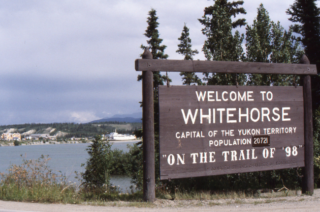
- June 1990: Welcome to Whitehorse.
- July 29, 1991: Major reconstruction of the South Access Road is scheduled for 1993, Whitehorse city council has been told. At its regular meeting last Monday night, council approved a $26,000 expenditure to cover its portion of an $80,262 study to look at
reconstruction options that include making room for a bicycle-walking path. The study will also examine the need and possibility of four lanes in the future.
- December 22, 1993: Whitehorse resident Geoff Capp suggested to council Monday night that the South Access Road be renamed the Gordon Armstrong Boulevard, after the name of the city's first mayor, who died last April. Capp told council he believes
the road was built during Armstrong's tenure from 1950 to 1957. The Star was unable this
morning to confirm the construction date. Coun. Doug Gallup told council he liked the idea of recognizing Armstrong, but feels the road will always be known as the South Access because its name is so deeply entrenched.
- June 13, 1994: Among the A-priority roadwork identified by City council is a $4.5-million commitment to reconstruct the South Access Road in 1996-97.
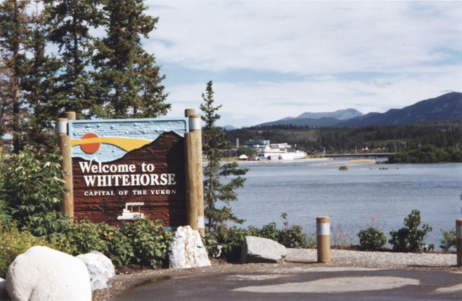
- August 31, 1994: The new South Access Road "Welcome to Whitehorse" sign will be unveiled at 2 p.m. Friday by Mayor Bill Weigand. The old sign (see photo at June 1990) was replaced due to physical deterioration and vandalism, having been there since 1974. It was donated to the Yukon Transportation Museum. The new cedar version will be moved seven metres east to allow for a better initial view of the city and for future improvements to the South Access Road, the Whitehorse Chamber of Commerce said Tuesday. A photo of the mayor with the sign appeared in the September 6 edition of The Star. The photo below shows it in July 2001.
- February 8, 1995: City council will consider naming two main road networks after a pair of the territory's literary giants. Council instructed administration Monday night to prepare a resolution to designate as Jack London Way the route that begins at the top of the South Access Road and runs along Fourth Avenue and up Two Mile Hill. It's also proposed that the name Robert Service Boulevard be applied to Second Avenue. But the intent is not to rename either Two Mile Hill or the South Access Road, Barb Toombs, chair of the Jack London Way Committee, told council. She emphasized that the existing names would remain as they are, with London and Service as additional names to describe routes, not specific streets.
- February 27, 1995: City council voted to rename Two Mile Hill, Jack London Way; and the South Access Road, Robert Service Way. It was in response to an initiative
by the Jack London Way Society last Fall to have two of the territory's renowned writers honored publicly. Community Services Minister Bill Brewster initially pointed out that his government is responsible for maintaining the roadways, so the cabinet would have to
approve any name changes. That turned out to be not true; a section in the
Municipal Act gives the municipality the right to name streets and roadways inside city limits. Brewster says he expects the existing names are so entrenched that they'll always be known as they are now.
- April 17, 1995: Vehicle crash reports have been common ever since the South Access Road opened, and there have been several fatalities. Opposition Leader Tony Penikett says there have been 32 accidents on the road just since 1990.
- May 10, 1996: On the City's list of projects is reconstruction of Robert Service Way (South Access) at a cost of $10,629,000. This money is scheduled to be spent evenly over 1997 and 1998 and is coming from the territorial government in exchange for Whitehorse taking over the maintenance of nine city roads.
- July 5, 1996: The City of Whitehorse cordially invites you to an Open House concerning the reconstruction of Robert Service Way and development opportunities for the south access. Reconstruction of Robert Service Way is planned for the summer of 1997. Options for land use development are also being planned. We want the south access road into Whitehorse to become a centrepiece and welcoming gateway as we roll out the red
carpet for visitors to the City.
- August 14, 1996: City council adopted a tentative reconstruction plan for Robert Service Way (South Access Road) Monday evening. It includes an option to relocate the White Pass rail line to the Yukon River's edge. Lengthy descriptions of the options and the White Pass response were published on August 14 and 16.
- September 17, 1996: City council accepted an administrative recommendation Monday evening to cancel the renaming of Two Mile Hill to Jack London Boulevard, but continue with the renaming of the South Access Road to Robert Service Way. Three of the four council members present said although they recognized the contribution Jack London made to the Yukon's profile world-wide, in light of recent criticism of the author, it would be best for the time being to postpone the name change.
- October 9, 1996: Relocating the White Pass railway tracks to the east side of Robert Service Way during reconstruction of the former South Access Road has been ruled out because of cost and possible conflict with future waterfront plans, says the city engineer.
- October 17, 1996: The South Access Road is no more. City council gave third and final readings Tuesday evening to its bylaw that officially changes the names of the city's southern access artery to Robert Service Way.
- November 29, 1996: Mayor Kathy Watson says she's supporting a complete road closure to provide for next's year's reconstruction of Robert Service Way (South Access Road). Partial closure would extend road construction to mid-June 1998, and add $450,000 to the project cost. No closure of the old South Access Road would push reconstruction completion to mid-August 1998, at an additional cost of $1.2 million.
- January 20, 1997: Tender documents for an estimated $9.13 million worth of construction work budgeted by the city for this year, scheduled for release today, have been put on hold indefinitely because the City did not provide critical information to the Department of Fisheries and Oceans. Acceptable replacement of salmon habitat is required by DFO before the city can obtain a water licence to expand Robert Service Way 25 metres into the Yukon River. Mayor Kathy Watson said Friday she's still optimistic that the project can proceed, although it possibly won't. Council voted last fall to close the road for about seven months to ensure all construction work is completed this year.
- March 12, 1997: The City of Whitehorse has been issued the water licence it required for reconstruction of Robert Service Way to begin but there is still opposition to the road required to do the salmon habitat work. The cost of the project has now climbed to $12.9 million. A full-page article describes the issues.
- March 18, 1997: Yet more doubt was thrown this morning on the proposed $12.9-million reconstruction of Robert Service Way, for which the contract proposals are to be received nine days from now. Kwanlin Dun Chief Joe Jack said this morning that for a number of reasons the first nation is rejecting a city proposal to use a piece of land
selected under Kwanlin Dun's land claim negotiations to access the river near F.H. Collins Secondary School.
- March 24, 1997: The reconstruction of Robert Service Way got the green light Friday with a triparte agreement between the city, the Kwanlin Dun First Nation
and the Yukon government. In exchange for employment considerations, Kwanlin Dun has agreed to permit a temporary road across a piece of land it's selected under land claims. The successful bidder will be required to try to employ Kwanlin Dun members during what's expected to be a six-month construction job.
- April 1, 1997: Golden Hill Ventures, one of four companies that bid on the reconstruction job, was the low bidder at $8.24 million, but a full assessment of their bid needs to be done before the contract will be awarded.
- April 9, 1997: The contract was awarded to Golden Hill Ventures this afternoon, with the McLean Lake quarry to be used. Quarry development work will begin Thursday, and Robert Service Way will be closed for approximately seven months starting April 19th. The City had planned a water taxi service from downtown to the Robert Service Campground but that has now been cancelled.
- April 18, 1997: Partly because of the closure of Robert Service Way, an ambulance will be stationed at the airport as of May 12, to reduce response time on the highway.
- April 18, 1997: A lengthy article on Page 4 describes the timing of the many components of the project.
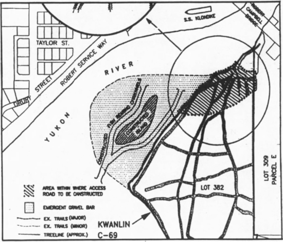
- April 1997: Preparing to start work on the major reconstruction of Robert Service Way. On the far side of the river, replacement salmon habitat is being constructed, as shown in the drawing below the photo.

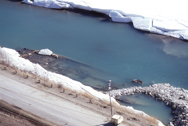
- April 1997: A rock/gravel ramp has been built down to the wreckage of the sternwheeler Canadian, in order to remove some significant pieces including the boiler.

- June 27, 1997: The expansion of Robert Service Way is on budget and on schedule. Drivers can expect to be travelling on the new asphalt by the end of August. The major excavation work at the Ear Lake intersection will see the road elevation dropped by 10-13 feet, with a much longer radius on the curve. The railway tracks that were torn up
below the clay cliffs will not be replaced until the White Pass and Yukon Route decides to reopen that section of line, if that ever happens. While it was not originally planned for, the walkway along the edge of the Yukon River that follows the roadway is now expected to be paved.
- July 11, 1997: A Letter to the Editor complains about the dangerous situation caused by the City of Whitehorse's authorization of plans to allow a near-vertical, unsupported silt slope over 100 feet high, commonly called the White Pass slope, to remain directly above the new South Access roadway.
- ca. July 20, 1997: The reconstruction is coming along very well.

- August 1, 1997: The newly-reconstructed Robert Service Way was reopened ahead of schedule this morning between Fourth Avenue and the Miles Canyon Road entrance. Motorists driving into the city along the Alaska Highway from southern points can now reach downtown via Miles Canyon Road.
- August 5, 1997: City engineer Mitch Moroziuk has gone to the city's lawyer to make sure Whitehorse has fulfilled its due diligence in protecting the public from possible falling silt on the Robert Service Way. The issue of the cliffs that overhang the road has arisen lately, as some members of the public have said they're unsafe. The city is sure there won't be a major collapse of the cliffs, but is worried about sloughing which may drop some silt on the road.
- August 11, 1997: The new Robert Service Way opens. The next day, a lengthy article described the opening ceremony at the Ear Lake road junction, with a photo of Mayor Kathy Watson cutting the ribbon, with Government Leader Piers McDonald, an RCMP officer on horseback and others looking on.


- November 4, 1997: The smooth new road is being tested by many drivers, and RCMP are handing out tickets as are City bylaw officers who have new radar equipment.
- November 19, 1997: Vehicle-activated traffic lights have been installed at Second Avenue and Robert Service Way, and on Saturday will go into operation, replacing the flashing red and yellow lights. Second Avenue traffic will have priority.
- January 8, 1998: The Yukon Agricultural Association has proposed building ab agriplex at the go-cart track across from Roert Service Campground. An agriplex would be used for rodeos, horse shows, agri-livestock shows, as well as a community centre, dance hall, meeting hall, bingo hall and concert area.
- May 20, 1998: Talmark Construction was given tentative approval for a $342,252 contract for site furnishing (whatever that is) along the road. Decora Landscaping has been given tentative approval for a $193,646 contract for landscaping along Robert Service Way. The river walkway will be closed for much of the summer to permit that work to be done.
- August 13, 1998: Skookum Asphalt Ltd. has been awarded the $1.2-million contract to put the second layer of asphalt on Robert Service Way. Skookum was the only company to submit a bid, which came in $174,000 below the engineer's estimate.
- October 14, 1998: Last year's Robert Service Way reconstruction project has been recognized as Canada's most environmentally-friendly project, as was awarded the Transportation Association of Canada Environmental Achievement award for 1997.
- October 21, 1998: A 120-meter section of the river trail is slipping into the river. The Department of Fisheries and the Yukon Water Board rejected the City's design for the rock embankment, and the design they accepted is now slipping into the river, with the rock settling into the most comfortable position. It may take 300 cubic meters of rock to repair next spring.
- October 21, 1998: Construction of a memorial to the sternwheeler Canadian along the river walkway has now been completed. A photo on the front page shows a worker making final adjustments.
- December 23, 1998: Seven of the Colorado blue spruce planted along Robert Service Way at great expense have been chopped down, apparently for Christmas trees. Replacing them could cost as much as $5,000.
- May 3, 1999: The river trail will be closed from May 3 until May 21 to allow for reinforcement of the rip-rap slope along the river.
- November 17, 2000: A Letter to the Editor by Allen Lueck is looking for support to get the old Whitehorse Inn sign installed at the junction of the Alaska Highway and Robert Service Way. It is 22 feet high, and Lueck has been storing it since the hotel was demolished in 1978. (about 15 years later, the sign was installed at the MacBride Museum)
- July 30, 2002: It's taken two years of debate, but city officials are deeming the paved Millennium Trail a success. The trail stretches 5 km along the Yukon River beginning at the Whitehorse Rapids fish ladder in Riverdale. The three-metre-wide trail continues through the skateboard park and connects with the Robert Service Way walkway which runs along the other side of the Yukon River. That portion of trail was extended alongside Robert Service Campground to the Yukon Energy site. Phase two of the trail project is planned to include a pedestrian bridge linking the ends of the trail, at a cost estimated at $400,000.
- November 5, 2003: A new City traffic control proposal includes plans for a round-about at Fourth Avenue and Robert Service Way. "A round-about is a circular roadway with various turnoffs. It is used as a intersection control technique to reduce vehicle delay, slow traffic and improve safety."
- June 12, 2004: The City of Whitehorse set up a live, to-scale replica roundabout so that the public could learn how to drive the new roundabout that will be constructed at Fourth Avenue and Robert Service Way before it is built.

- July 9, 2004: Tenders are called for construction of a roundabout at Fourth Avenue and Robert Service Way. Skookum Asphalt was awarded the contract.
- October 1, 2004: A 3/4-page article about the City's two new roundabouts, the first one on Hamilton Boulevard and the second on Robert Service Way, includes photos of both and explains how to use them. It reports a positive response from the public. A 1/2-page ad in the same issue has a detailed diagram and instructions on how to use them.
- November 19, 2004: The City has applied to subdivide a 14.1 hectare parcel of land located off the Robert Service Way that is currently used as a snow disposal site under a lease agreement between the City and the Yukon Government. The subdivision area also contains a lease area to the Midnight Sun Dirt Riders Association, The land is to be transferred to the City from the Yukon Government after subdivision is complete.
- January 11, 2005: Although Ketza Construction won the $789,041 contract to build the Rotary Centennial Bridge, inability to get the steel delayed the project. With materials now in place, it is going to be built in February. It will make the Millennium Trail a circular path.
- February 14, 2005: The City has committed to secure funding approval under the federal Municipal Rural Infrastructure Fund to cover the cost of extending Hamilton Boulevard to meet with Robert Service Way in 2008, including coming up with its one-third share of the cost as required by the infrastructure fund, to a maximum of $3.5 million.
- April 6, 2005: Whitehorse RCMP will be conducting random educational check-
stops at the city's two roundabouts later this week, to promote awareness among motorists on the proper use of the traffic controls. Motorists can be fined up to $145 for failing to signal when exiting a roundabout.
- June 28, 2005: Two major rainstorms this month had the City scrambling to deal with erosion along Robert Service Way at the clay cliffs, and the along the walking trail.
- July 1, 2005: The first Billy Bog's Mud Bog is held at the go kart track on Robert Service Way.
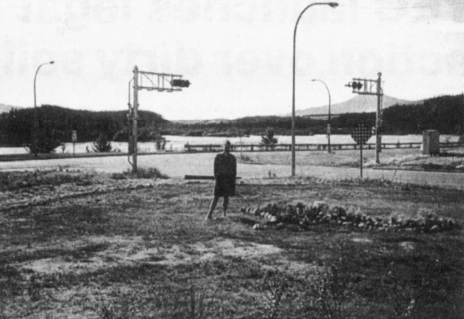
- July 29, 2005: A full-page article with 3 photos describes the garden that Will Petricko has spent the past 13 years creating at the northeast corner of Fourth Avenue and Robert Service Way. Petriko left the territory last fall, and the City has now agreed to take over maintenance of it. The photo below shows what he started with.
- July 4, 2006: Heavy rains damaged an eagle's nest at the Millennium Trail pullout on Robert Service Way, causing two baby eagles to fall out of their nest last
Thursday. Fortunately for the eaglets, some plants broke their 10-metre (33-foot) fall and they weren't hurt. Conservation Officer Tony Grabowski called Yukon Electrical Co. for a bucket truck so a crew could repair the nest and replace the eaglets and within a few hours a 5-man team had repaired the nest, returned the eaglets, and life was normal again. The adult eagles circled the activity but made no attempt to interfere.
- March 23, 2007: Environment Yukon, the Yukon Electrical Co. Ltd. and
Klondike Welding partnered to erect a new nest on a pole as a stable nesting area for the bald eagles, to replace the one damaged last July. Yukon Electrical and Klondike Welding donated all of the material, equipment, and labour.
- July 4, 2007: The City of Whitehorse advises that from July 3 to July 8, the Robert Service Way River Walkway will be closed to the public to allow for the reinforcement of the rip-rap slope immediately to the east of the binwall. On July 10th it was reported that those repairs had cost $50,000.
- July 20, 2007: Tenders are called for clearing and grubbing of the road right-of-way from end of existing Hamilton Boulevard to intersection of Alaska Highway and Robert Service Way. We have posted a gallery of 25 photos that document the construction - see "Building the Hamilton Boulevard Extension, 2007-2009."
- July 20, 2009: Traffic control lights have replaced the stop signs at the intersection of Robert Service Way, the Alaska Highway, and the new Hamilton Boulevard extension. The new road was officially opened on August 5th.
- October 17, 2011: A memorial to the sternwheeler Canadian, with the replica paddlewheel at centre left and the replica bow at lower right.

- December 13, 2011: Year after year, photos of vehicles crashes on Robert Service Way regularly appear on the front page of The Star.
- September 21, 2012: A general view from the slope above.

- May 15, 2014: After a couple of years of heated controversy, Yukon Energy's proposal to build a $42-million LNG power generating facility along Robert Service Way has been given unconditional approval by the Yukon Utilities Board. Protests continue, however.
- February 3, 2017: Jane of All Trades Consulting has been awarded a $67,309 contract that will consider the future of the area along and around Robert Service Way, including Ear Lake, the ball diamonds, the dirt bike track, Robert Service Campground, and Bert Law Park.
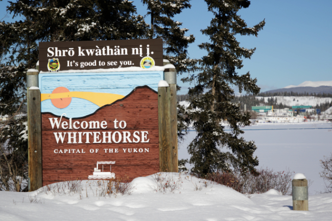
- March 7, 2018: The Yukon Arts Centre has donated $5,000 to the City for the inclusion of Southern Tutchone to the Welcome to Whitehorse signs on Robert Service Way and Two Mile Hill. The signs were installed on November 1st.
- May 12, 2019: Another look at the memorial to the sternwheeler Canadian, and the Millennium Trail.

- May 29, 2019: Two men from Alaska were killed when their single-engine Cessna crashed and burned immediately after takeoff, between the runway and the dirt bike track along Robert Service Way.
- February 22, 2021: Yukon Energy has chosen a piece of land at the northeast corner of the Alaska Highway and Robert Service Way for their new battery storage facility. It will be accessed from a new road to be built from Robert Service Way.
- February 22, 2021: This year's extremely heavy snowfall has resulted in the snow dump at the bottom of Robert Service Way looking quite full. Snow removal crews have been working around the clock to try to keep up. Only once in the last 10 years has there ever been the need for a bulldozer, and this is the first year crews have brought in a Snowcat.
- December 17, 2021: A tentative proposal to build a massive roundabout on the Alaska Highway where it meets Robert Service Way and Hamilton Boulevard is being panned on social media, but the Yukon government says it would enhance safety.
- May 2, 2022: The biggest local landslide in decades has closed Robert Service Way for an indeterminate amount of time. The clay banks near the eagles' nest gave way at approximately 3 p.m. Saturday (April 30th), sending a torrent of mud and debris across the road and the Millennium Trail and onto the ice on the Yukon River. The road has been closed since, as City of Whitehorse officials try to gauge how dangerous the situation is. Work to clean up the mess won't begin until the site is deemed safe.
- May 18, 2022: Whitehorse Transit has suspended bus fares to encourage ridership and reduce peak-time traffic congestion during the road closure.
- May 27, 2022: Initial cleanup of the Apr. 30 mudslide along Robert Service Way is essentially complete. Construction of a metal sheet piling wall was set to begin today, with construction anticipated to last seven to 10 days, weather permitting.
- June 9, 2022: Installing the slide barrier.

- June 15, 2022: Installation of the sheet piling wall has been completed, and Robert Service Way will be re-opened tomorrow evening. That section of the Millennium Trail will remain closed.
- September 22, 2022: The completed slide barrier.


- April 8, 2023: Another landslide about 01:00 has blocked one lane of Robert Service Way and put debris in the other lane. The road is closed until a geotechnical assessment can be conducted.

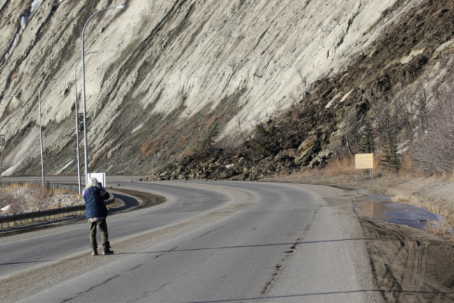

- May 4, 2024: What the City termed a "minor" slide came down just before noon, reaching the top of a barrier wall installed in the previous few days.

The photo below shows the slumping happening towards the south end of the most unstable section, above the sheet piling wall installed in June 2022.

May 6, 2024: Harjit Sajjan, the federal minister of Emergency Preparedness, was in Whitehorse to announce $46 million in funding to deal with the escarpment slides. Robert Service Way and the Millennium Trail will be moved further from the base of the escarpment, the slope will be regraded and vegetation planted, and the debris barrier will be expanded.
|

|
