Highlights of History from The Whitehorse Star
An Explorer's Guide to the South Klondike Highway
Dateline: January 16, 2024. Last update: March 10, 2024.
The Whitehorse Star, Monday, June 8, 1970
(The following fact sheet, prepared June 1, 1970 by Al Wright of the Whitehorse Chamber of Commerce Transportation Committee, was presented to members at Tuesday's luncheon meeting. It is based on the D.P.W. (Canada) Study of November, 1966.)
POINT OF ORIGIN - Mile 909 Alaska Highway
DESTINATION - Skagway, Alaska
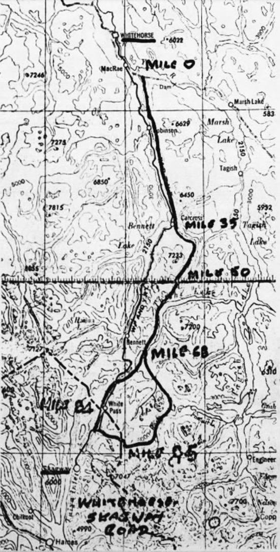
PROPOSED ROUTES
(a) Warm Pass Route
(b) Tutshi Valley Route - American "West White Pass Route"
Other routes were considered (i.e. White Pass, Lake Bennett, etc.), but were rejected as too costly.
DETAILS OF ROUTES
(a) Section Common to Both Routes (Mile 0 - 68)
Mile 0 - 35 - Alaska Highway to Carcross via existing road
Mile 35 - 50 - Carcross - B,C, Boundary via Windy Arm
Mile 35 - 68 - B.C. Boundary to North End of Tutshi River Valley via Tutshi Lake
(b) Warm Pass Route
Mile 68 - 95 - to International Boundary via Warm Pass
(c) Tutshi Valley Route
Mile 68 - 84 - to Interanational Boundary via Tutshi River Valley, Summit Lakes and un-named defile west of White Pass
(d) Alaska
Descends from either Warm Pass or White Pass West and follows Skagway River
DISTANCES
(a) Warm Pass Route
| |
In Y.T. (from Alaska Highway)
In British Columbia
Total in Canada
In State of Alaska
Overall distance (new road)
Total Whitehorse - Skagway
|
50 miles
45 miles
95
14
109
118
|
(b) Tutshi Valley Route
| |
In Y.T. (from Alaska Highway)
In British Columbia
Total in Canada
In State of Alaska
Overall distance (new road)
Total Whitehorse - Skagway
|
50 miles
34 miles
84
12
96
105
|
Note: For comparison, White Pass & Yukon Route, Whitehorse
- Skagway - 110 miles.
SAVING IN DISTANCE - Route (b) over (a)
In Canada - 11 miles
In Alaska - 2 miles
Total 13 miles
MAXIMUM ELEVATION
(a) Warm Pass Route - 3900 feet
(b) Tutshi Valley Route - 3200 feet
ROAD BUILDING MATERIALS
Very generally - sand, silt and gravels along existing road to Carcross; some rock outcrops along Windy Arm and Tutshi Lake, but granular material and boulders in benches and fans; Warm Pass Route very rocky, but possible gravels in glacial moraines and fans; and risk of rock and snow slides; Tutshi Valley route follows about nine miles of sand and gravel eskers, remainder of distance to boundary predominantly rock.
The section of the road in Alaska is predominantly rock.
In the coast range portion of both routes, a snow fall is very heavy, varying in some locations from 200-400 inches.
PROPOSED DESIGN STANDARDS
I.A.N.D. Truck Road Standards
Design speed - 60 m.p.h.
Maximum grades - 6%
Maximum curvature - 6°
Roadway width - shoulder to shoulder - 32 feet
Bridge design - H20 - S16
In some sections short stretches of grades up to 8 - 9% will be necessary for economic reasons, and some increases in maximum curvature may also be necessary.
Note: In Y.T., the road from Dawson City to the Clinton Creek Mine is built to trunk road standards.
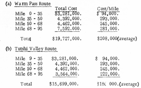
ESTIMATED CONSTRUCTION COSTS (1966)
Note: In the D.P.W. Study, the cost estimates were developed to the flexible pavement stage. For the purposes of this presentation, these cost elements were removed from the estimate, and construction is considered only to the stage of an application of traffic gravel. Earthwork and rock quantities used in arriving at these costs were estimated from profiles of the proposed centre lines projected on blow-ups of 1:50,000 maps of the area (i.e. approximately 1¼ inches to one mile) with interpolated contour intervals. Five per cent is added for contingencies, and 10% for engineering costs.
COMMENTS
This section of necessity departs from the factual. These are preliminary estimates only, and more accurate figures would only be forthcoming from a detailed route survey. However, it should be noted that since 1966 the construction of the Venus Mine's access road to area development road standards, with a 24 foot wide roadway surface, and the construction of a new bridge at Carcross, have extended the useable road from Mile 35 to Mile 47.5, requiring the construction of only a further 2.5 miles of road to complete the Yukon section. This will of course considerably reduce the costs to bring the mile 35-50 portion to trunk road standards. In addition, it is felt that the estimate for upgrading the mile 0-35 section is high, and figures of $60,000./mile for this section (which will have to be largely rebuilt) and $40,000./mile for upgrading the Venus Mines Road would be more realistic, with a total cost for the Tutshi Valley route of approximately $12,000,000.
It is also felt, however, that in view of the rugged terrain and the fact that it is hoped that this road will attract considerable tourist traffic, all new construction in future should be to the recommended trunk road standards, and the existing
road should be ultimately upgraded.
No attempt is made to estimate the Alaska construction costs.
CONCLUSIONS
A road from the Alaska Highway to Skagway is practicable, but will be costly because of the amount of rockwork and costly gorge crossings, which conditions are encountered mostly in the lower portion of the B.C. section and in Alaska.
Agreement in principle has been reached between Canadian and American ae authorities that for both countries the so-called Tutshi Valley or West White Pass route would entail the most economical and desirable construction.