Arctic & Northern Nature & Environment
Dateline: March 7, 2024.
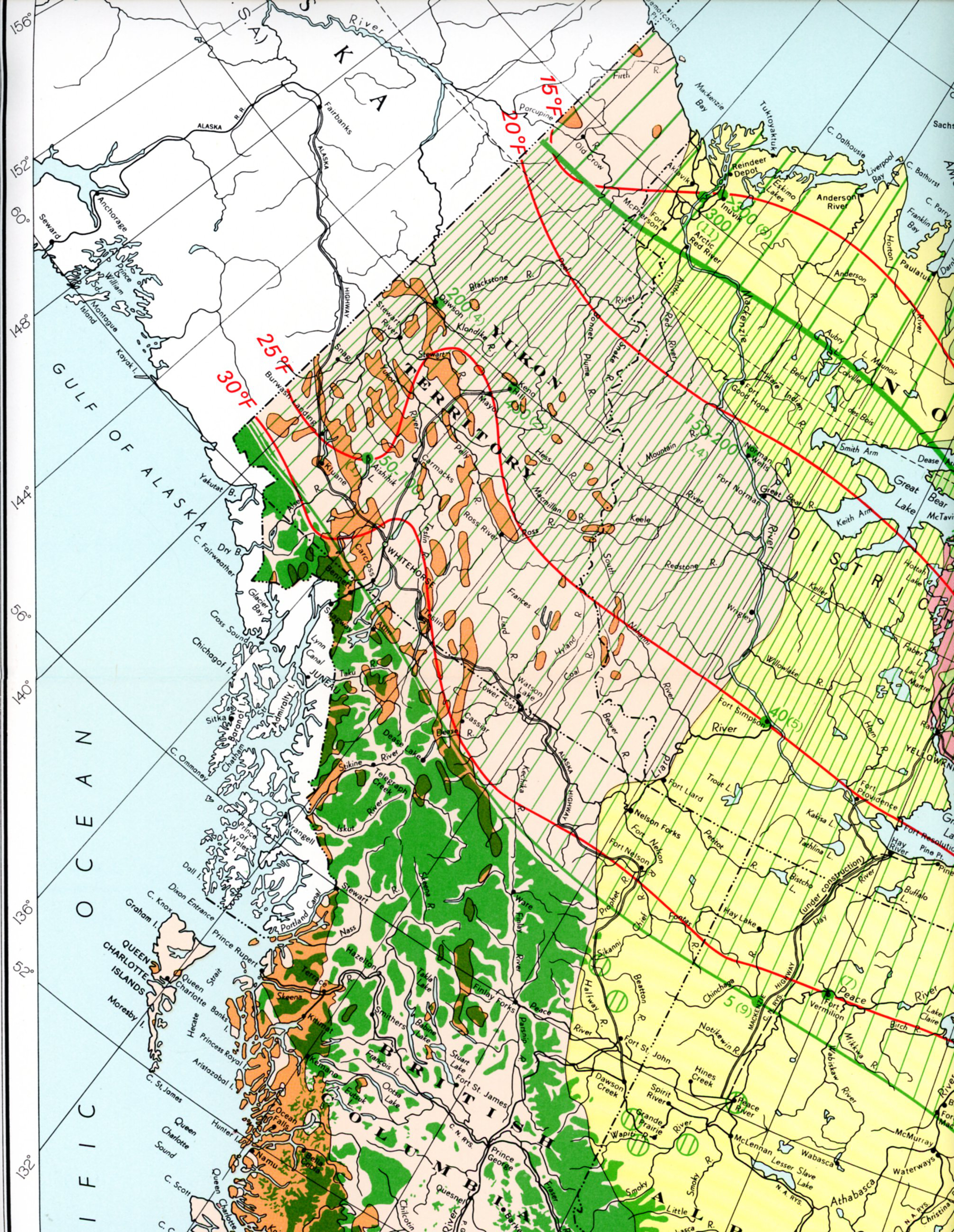
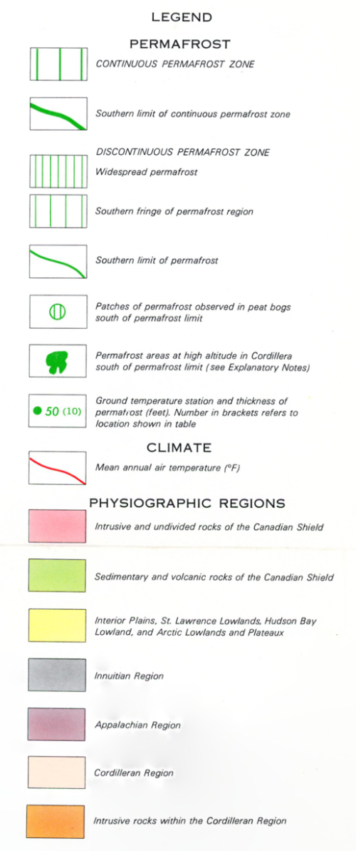
This map is a section of "Permafrost in Canada," a 32x40-inch map published jointly in 1967 by the Geological Survey of Canada and the National Research Council of Canada's Division of Building Research (Map 1246A). The extremely detailed text that follows below is from that map.
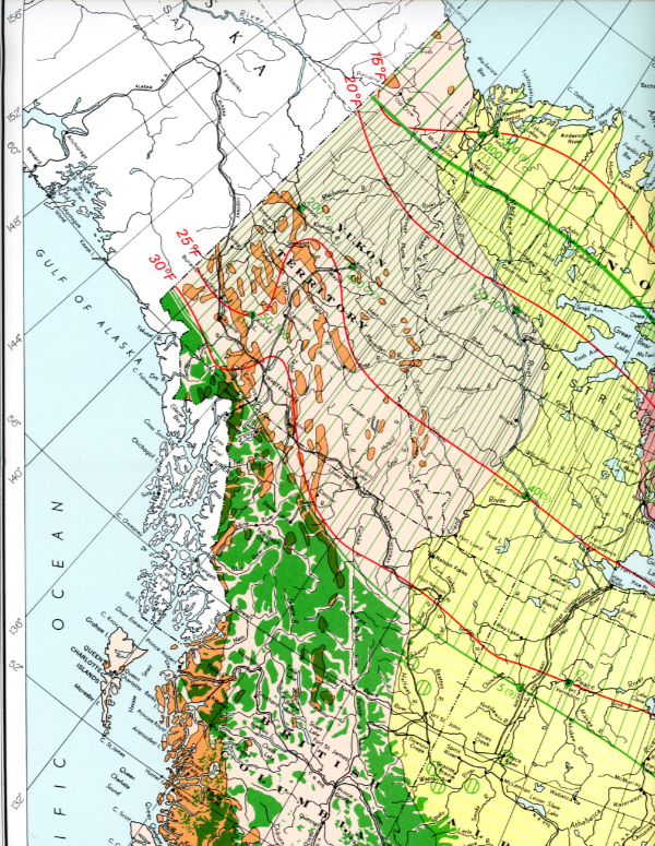
Click on the map to greatly enlarge it in a new window.
DEFINITION OF PERMAFROST
Permafrost, or perennially frozen ground, is defined exclusively on the basis of temperature and refers to the thermal condition of earth materials such as soil and rock when their temperature remains below 32°F continuously for a number of years. Permafrost includes ground which freezes in one winter, remains frozen through the following summer and into the next winter. This is the minimum limit for the duration of permafrost; it may be only a few inches thick. At the other end of the scale, permafrost may be thousands of years old and hundreds of feet thick. The mode of formation of such old and thick permafrost is identical to that of permafrost only recently developed.
Even a small negative heat imbalance each year results in a thin layer being added annually to the permafrost. This annually repeated process can produce a layer of permafrost hundreds of feet thick after several thousands of years. This process does
not cause the permafrost to increase in thickness indefinitely but a quasi-equilibrium is reached whereby the downward penetration of frozen ground is balanced by the flow of heat
from the unfrozen ground below. Permafrost is not "permanently" frozen. Changes in climate and terrain can cause the permafrost to thaw and disappear.
DISTRIBUTION AND OCCURRENCE OF PERMAFROST
The permafrost region is divided into two zones - continuous and discontinuous. The division between these zones was chosen arbitrarily by Russian permafrost investigators as the -5°C (23°F) isotherm of mean annual ground temperature measured just below the zone of seasonal variation (level of zero annual amplitude). This criterion has been adopted in North America.
In the discontinuous zone, there are areas and layers of unfrozen ground. In the southern fringe of this zone, permafrost occurs in scattered islands a few square feet to several acres in size and it is confined to certain types of terrain, mainly peatlands. Other occurrences are associated either with north facing slopes or forested stream banks where increased shading from summer thawing and reduced snow cover enhance permafrost development. Northward, permafrost becomes increasingly widespread and is associated with a greater variety of terrain types.
Permafrost varies in thickness from a few inches or feet at the southern limit to about 200 feet at the boundary of the continuous zone. Unfrozen layers may occur between layers of permafrost. The depth to the permafrost table is extremely variable
ranging from about 2 feet to several tens of feet. The active layer does not always extend to the permafrost table. The temperature of the permafrost at the level of zero annual amplitude generally ranges from a few tenths of a degree below 32°F at the southern limit to 23°F at the boundary of the continuous zone.
In the continuous zone, permafrost occurs everywhere beneath the ground surface except possibly in newly deposited unconsolidated sediments where the climate has just begun to impose its influence on the ground thermal regime. The thickness of permafrost varies from about 200 feet at the southern limit of the continuous zone to more than 1000 feet in the northern part of the zone. The active layer, which freezes in winter
and thaws in summer, generally varies in thickness from about 1½ to 3 feet and usually extends to the permafrost table. The temperature of the permafrost at the level of zero annual amplitude ranges from 23°F in the south to about 5°F in the extreme
north.
Cordillera
In the Cordillera, the distribution of permafrost varies with altitude as well as latitude. On the map, the southern limit of permafrost marks approximately the boundary of permafrost occurrence at valley bottom levels. South of this line, permafrost
is not present in lowlands and valley bottoms but exists at higher altitude. The lower altitudinal limit of permafrost rises progressively from north to south. With increasing elevation the distribution of permafrost changes progressively from scattered islands to widespread and finally continuous.
Moreover, in mountainous regions permafrost is more widespread and thicker on north facing slopes than south facing slopes. Snow cover, which has considerable influence on permafrost, varies in thickness between windward and leeward slopes. Other terrain factors also vary from one slope to another and complicate the distribution of permafrost.
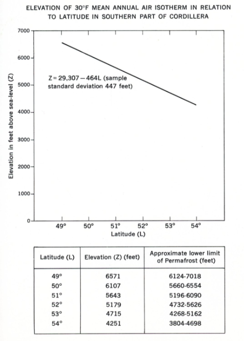
Throughout the northern part of British Columbia, south of the southern limit of permafrost on the map, field observations indicate that the lower limit of permafrost is uniformally at an elevation of about 4000 feet. Below this elevation, scattered permafrost islands occur only in specific types of terrain. Throughout the southern part of the Canadian Cordillera the lower altitudinal limit of permafrost has been estimated by analyzing the variation with latitude of the elevation of the 30°F
mean annual air isotherm.
The elevation of this isotherm at a given meteorological station was estimated on the basis of a 1°F decrease in mean annual air temperature per 300 feet increase in altitude. The line (z = 29,307 - 464L) shown in the accompanying figure was fitted to records from 169 stations by the method of least squares. The sample standard deviation about the line is estimated to be 447 feet. Thus, at any given latitude, the lower limit of permafrost will probably be encountered somewhere within 450 feet above and below the elevation derived from the equation. For example, at latitude 49°N, L = 6571 feet. Thus the lower limit of permafrost lies probably between 6571 - 447 = 6127 ft and 6571 + 447 = 7018 feet or about 6100 to 7000 feet above sea level.
It is believed that permafrost occurs at the summit of Mont Jacques-Cartier (4160 ft) in the Gaspe Peninsula. This is the highest elevation south of the permafrost limit in eastern Canada. It is suspected of being the only location in this region at sufficiently high altitude to support the existence of permafrost.
Relic Permafrost
Along the southern limit of permafrost, known occurrences seem to be in reasonable equilibrium with the present environment. No relic occurrences, which represent radically different conditions, have yet been described south of the permafrost region. There are a few random reports, however, of isolated bodies of permafrost lying at depth beneath the ground surface. lf such permafrost does exist, it probably formed during a former period of cooler climate and lies at a depth below that affected by the present climate. There is no evidence on the ground surface of these bodies of permafrost. They would be detected only by mining operations or ground temperature measurements. Farther north in the permafrost region, occurrences of relic permafrost at depth are known.
PHYSICAL FACTORS INFLUENCING DISTRIBUTION AND OCCURRENCE OF PERMAFROST
Climate
Climate is basic to the formation and existence of permafrost. Observations indicate a broad relation between mean annual air and ground temperatures in permafrost regions. The complex energy exchange regime at the ground surface, and the
snow cover cause the mean annual ground temperature, measured at the level of zero annual amplitude, to be several degrees warmer than the mean annual air temperature. Local micro-
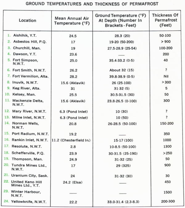
climates and terrain conditions cause variations but a value of 6°F can be used as an average figure (see table of ground temperature stations).
Present knowledge of the southern limit of permafrost indicates that it coincides roughly with the 30°F mean annual air isotherm. West of Hudson Bay, the southern limit on the map is based on a considerable number of field observations. East
of Hudson Bay, there have Leen few field observations as yet and so the southern limit is shown to coincide with the 30°F mean annual air isotherm. Southward, permafrost occurrences are rare and small in size because the climate is too warm. Between the 30°F and 25°F mean annual air isotherms, perma- frost is restricted mainly to the drier portions of peatlands and peat bogs because of the special insulating properties of peat. Scattered bodies of permafrost also occur on some north facing slopes and in some heavily shaded areas.
In the vicinity of the 25°F mean annual air isotherm, the difference of 6°F between the mean annual air and ground temperature produces a mean annual ground temperature of a fraction of a degree below 32°F in most types of terrain. From
the 25°F mean annual air isotherm, northward to the continuous zone, permafrost becomes increasingly widespread and thicker, and the mean annual ground temperature decreases.
There is virtually no precise field information on the boundary separating the discontinuous and continuous zones. The line on the map is situated at the approximate location of the 17°F mean annual air isotherm to correspond with a mean annual ground temperature of 23°F. Field observations along the coast of Hudson Bay in Ontario and Manitoba indicate a narrow band of continuous permafrost south of the 17°F mean annual air isotherm. From this isotherm northward, permafrost is continuous and increasingly thicker, and the mean annual ground temperature decreases.
At Resolute in the Arctic Archipelago, the mean annual air temperature is 3°F and the mean annual ground temperature is 9°F. Variations in cloud cover throughout the permafrost region may cause significant differences in the amount of solar radiation received by the ground surface and may influence the distribution of permafrost but no detailed information is available.
Terrain Influences
The broad pattern of permafrost distribution is determined by climate but local terrain conditions are responsible for the patchy occurrence of permafrost in the discontinuous zone and variations in thickness of the active layer in the continuous zone.
These variations in permafrost occurrence are governed predominantly by local variations in microclimate and such features of the terrain as relief, vegetation, drainage, snow cover and soil type.
Relief influences the amount of solar radiation received by the ground surface. The influence of the degree and orientation of slope is particularly evident in the Cordillera but smaller scale variations cause similar situations elsewhere in the permafrost region. In the discontinuous zone, this may result in permafrost occurring on north facing slopes but not on adjacent slopes facing south. In the continuous zone, permafrost is thicker and the active layer thinner, on north facing slopes.
Vegetation affects permafrost in various ways and is one of the more obvious indicators of subsurface conditions. It shields the permafrost from the thawing effects of summer air temperatures. This protection is provided mainly by the insulating
properties of the widespread moss cover. Removal or even disturbance of this surface cover results in degradation of the underlying permafrost. In the continuous zone the permafrost
table will be lowered. Trees are of some importance in shading the ground from solar radiation and intercepting some of the snowfall in winter, both factors tending to favour permafrost formation. The influence of vegetation is greatest in the discontinuous zone and diminishes northward in the continuous zone.
Drainage and the existence of large bodies of water greatly influence the distribution and thermal regime of permafrost. In the discontinuous zone, the existence of permafrost is inhibited in poorly drained areas. Moving water is an effective erosive agent of perennially frozen soils. An unfrozen zone exists beneath water bodies that do not freeze to the bottom. The extent of this thawed zone varies with a large number of
factors - area and depth of the water body, water temperature, the thickness of winter ice and snow cover, the general hydrology, and the composition and history of accumulation of bottom sediments. The ocean has an important thermal influence on permafrost causing it to be thinner at the shore than inland.
The type of soil and rock has considerable influence on the permafrost particularly in the continuous zone. Vegetation and other terrain factors assume a relatively minor role and the thermal properties of the ground as a whole, together with the climate become dominant. Variations in thermal properties such as reflectivity, conductivity, diffusivity and specific heat affect the thickness and temperature of the permafrost.
Snow cover influences the heat transfer between the air and the ground and hence affects the distribution of permafrost. The snowfall regime and the time that snow lies on the ground are critical factors. A heavy fall of snow in the autumn and early winter will inhibit winter frost penetration. On the other hand, a thick snow cover that persists on the ground in the spring will delay the thawing of the underlying ground. The relation between these two situations determines the net effect of snow cover on the ground thermal regime. In the discontinuous zone, particularly the southern fringe, it can be a critical factor in the formation and existence of permafrost. In the continuous zone,
it will influence the thickness of the active layer. In the Cordillera, snowfall is heavier on windward west facing slopes of the mountain ranges than on their leeward east facing slopes. This may be an additional complicating factor in the distribution of permafrost in this region.
Glaciers and ice caps affect the distribution of permafrost, the temperature at the bottom of the ice influencing the thermal regime of the underlying ground. It is postulated that the bottom temperature beneath most glacier ice is below 32°F. In temperate glacier conditions, the ice bottom temperature is at the pressure melting point - a fraction of a degree or more below 32°F. In polar glacier conditions, the bottom of the ice is frozen to the underlying ground and the temperature at the ice-ground contact is below 32°F. Thus in both cases a permafrost temperature condition could form beneath glaciers and ice-caps. This is an important factor in Canada because most of the country was covered with Pleistocene ice sheets, remnants of which persist today in the Cordillera and Arctic Archipelago.
DISTRIBUTION AND OCCURRENCE OF PERMAFROST IN PHYSIOGRAPHIC REGIONS
Canadian Shield
The terrain consists of rock knobs interspersed with poorly drained depressions. Soil cover on the rock knobs is generally thin or absent consisting of glacial deposits, lake and marine silts and clays. The same soils occur in the depressions and are commonly overlain by peat. In the southern fringe of the discontinuous zone, permafrost islands occur in the better drained portions of bogs and peatlands. Northward, the permafrost increases in extent and in the continuous zone it is found in the bedrock.
Hudson Bay Lowland
This is a low flat area and beach ridges formed during post-glacial marine submergence are the only major relief features. Drainage is poor between river valleys. Soils consist of thick peat deposits overlying marine sediments and till. Local microrelief features include spruce islands, palsas, peat plateaus, ridges and hummocks. The lowland lies within the discontinuous zone except for a narrow strip along the Hudson Bay coast in the continuous zone. In the discontinuous zone, permafrost occurs in scattered islands mostly in the better drained microrelief features.
Interior Plains
The relief is rolling with isolated highlands. Soils are predominantly fine-grained. In the southern fringe of the discontinuous zone, permafrost occurs in scattered patches in peatlands; further north it becomes more widespread. Only the extreme northern portion lies in the continuous zone. It appears that permafrost does not exist beneath the Mackenzie River or water bodies in its delta.
Cordillera
The terrain is mountainous consisting of ranges, plateaus, and intermontane valleys and trenches. The distribution of permafrost is greatly complicated by the relief as described above.
Arctic Archipelago
This region comprising the Arctic Lowlands and Plateaux, Innuitian Region and the northern part of the Canadian Shield lies entirely within the continuous permafrost zone except possibly the southeast tip of Baffin Island. The active layer is
thin and the permafrost is hundreds of feet thick.