The Squaw Creek area in the pocket formed by the Yukon-British Columbia boundary and the Alaska Panhandle may prove to be another Klondike, in the opinion of mining men who have received additional advices from that district. (The Whitehorse Star) Read the entire article here.
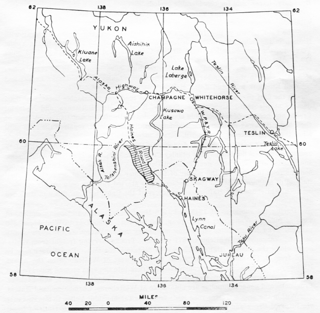
 The Squaw Creek-Rainy Hollow area, consisting of about 750 square miles of mountainous country, lies within the Atlin Mining Division in north-western British
Columbia (see map below). The area is a north-westerly trending belt about 45 miles long
and 10 to 20 miles wide lying along the Haines "Cut-off" Road. It extends from the
Alaska-British Columbia Boundary in the vicinity of the Klehini River (approximately
59° 25' north, 136° 20' west) to the Yukon Boundary in the vicinity of the Tatshenshini and Blanchard Rivers (60° north, approximately 137° west).
The Squaw Creek-Rainy Hollow area, consisting of about 750 square miles of mountainous country, lies within the Atlin Mining Division in north-western British
Columbia (see map below). The area is a north-westerly trending belt about 45 miles long
and 10 to 20 miles wide lying along the Haines "Cut-off" Road. It extends from the
Alaska-British Columbia Boundary in the vicinity of the Klehini River (approximately
59° 25' north, 136° 20' west) to the Yukon Boundary in the vicinity of the Tatshenshini and Blanchard Rivers (60° north, approximately 137° west).
The Squaw Creek-Rainy Hollow area contains no permanent settlements. During the winter it is entirely uninhabited, but usually during the summer and early part of autumn placer miners live on Squaw Creek. At that time of year Mrs. F. Muncaster, of Squaw Creek, acts as Sub-mining Recorder for the district. The office of the Gold Commissioner and Mining Recorder for the mining division is at Atlin.
HISTORY OF DEVELOPMENT.
Long ago the Chilkat Indians of the ancient village of Klukwan and of other settlements in that vicinity had a well-established foot-path, leading through the Squaw Creek-Rainy Hollow area, over which they journeyed to the interior to trade with other tribes. In 1882 Arthur Krause of the Bremen Geographical Society explored this old route of travel which led up the Chilkat and Klehini Rivers, across Stonehouse Creek, down
Nadahini and Mansfield Creeks, and up the Blanchard River into the Yukon Territory. His sketch-map, which is remarkably accurate, is incorporated in a map accompanying Dawson's report of 1887.
In 1896 Jack Dalton established a trail from Pyramid Harbour, on Chilkat Inlet, to the confluence of the Nordenskiold and Lewes Rivers in the Yukon Territory. This
trail, which followed much of the old Indian foot-path through the Squaw Creek-Rainy Hollow area, became known as the Dalton Trail. Some years previously Mr. Dalton had established trading-posts at Pleasant Camp on the Klehini River and at Dalton Post on the Tatshenshini River (Brooks, 1900, p. 342).
In 1897 J. J. McArthur surveyed the Dalton Trail, and his work was embodied in a revised edition of Dawson's map published in 1898.
From 1897 to 1899 hoards of gold-seekers en route to the Klondike travelled through this region over the well-worn Dalton Trail. In the summer of 1898 important deposits of placer gold were discovered on Porcupine Creek by a small party of these prospectors, who were delayed on their way to the interior by high water on the
Klehini River and by lack of provisions. In the autumn of that year, copper float that was found near the Dalton Trail at Rainy Hollow attracted attention to the area and a few claims were staked. In the following year 230 locations were made at Rainy Hollow. By 1899 a wagon-road, part of which followed gravel-bars along the Klehini River, extended from Pyramid Harbour, on Chilkat Inlet, via Porcupine to Pleasant Camp.
At this time development of mineral properties in the Rainy Hollow and Porcupine districts was hindered to some extent by uncertainty regarding the position of the British Columbia-Alaska Boundary. This uncertainty arose from the dispute then in progress on the interpretation of a treaty made in 1825 between Great Britain and Russia. In 1899 a temporary working agreement was drawn up and a provisional boundary was fixed along the Klehini River. In 1903 the present British Columbia-Alaska Boundary was established and the Porcupine placer deposits definitely came under Alaskan jurisdiction (Howay, 1914, pp. 551-556).
In 1908 and 1909 the Alaska Iron Company tested some properties near Copper Butte in the Rainy Hollow district with a shot drill and shipped a few tons of high-grade copper ore. At this time a wagon- road was being built by the Provincial Government from the International Boundary to Rainy Hollow.
In 1909 copper-bearing magnetite deposits were discovered in the Three Guardsmen region situated a few miles east of Rainy Hollow.
In 1911, 30 tons of ore yielding 1,657 oz. of silver and 19,161 lb. of copper was shipped from the Maid of Erin property in Rainy Hollow.
In 1914 a flurry of excitement was caused when many prospectors stampeded to the Klehini River in search of gold. Although more than 100 placer claims were staked, none yielded gold in paying amount and they were soon abandoned. By this time a good wagon-road extended from Haines, on Chilkoot Inlet, along the southern side of the Klehini River to Pleasant Camp and thence along the northern
side to Rainy Hollow.
In 1915 a gold-bearing quartz vein was discovered near Jarvis Glacier a few miles west of Pleasant Camp.
During the years 1920 to 1922 considerable development-work was done on the Maid of Erin property and about 100 tons of ore was Shipped. During this period the
Alaska Road Commission rebuilt the road from Haines to Wells, constructed a bridge across the Chilkat River, and extended the road along the northern side of the Klehini River toward Pleasant Camp.
In 1927 coarse gold was discovered on Squaw Creek by an Indian from Klukshu, and subsequently the creek became an important producer of placer gold.
In 1928 some diamond-drilling was done on the Maid of Erin property at Rainy Hollow.
In 1928 and 1929 the Alaska Juneau. Gold Mining Company held an option on a group of claims near Jarvis Glacier on which gold-bearing quartz veins had been found
and did extensive exploratory work on them.
In 1937 much attention was drawn to the Squaw Creek placers by the discovery of a nugget weighing 46 oz. 5 dwt.
During 1942 and 1943 the United States Army constructed the military highway known as the Haines "Cut-off" Road, which passes through the Squaw Creek-Rainy
Hollow area. Beginning. in 1944 prospectors and the Squaw Creek placer miners have used the Haines Road to reach the area from the Alaska Highway and from Haines; more use of the road was made by the prospectors and miners in 1945 than in 1944 or 1946.







 May 31, 1929: