History of the Alaska Highway
The Dispatch (Moline, Illinois) - January 21, 1942
By WILLIAM A. BAKER JR.,
Central Press Writer.
Washington - With Japanese vessels reported in Alaskan waters, attention is drawn to the proposed Alaska highway which has been under consideration by the United States and Canada since 1929. The highway is advocated primarily to meet a situation which now seems imminent. Its proponents have contended that it would be badly needed as a supply line if sea lanes between Seattle and Alaskan ports should be menaced by enemy warships or airplanes.
With from three to fifteen years estimated as the time required for construction of the road, it does not seem likely that it could be utilized to aid Alaska in this war, even if work were commenced immediately. Such a highway has been favored by high government authority as a re-employment project after the war.
The United States would be expected to foot most of the bill. It is estimated that a gravel road safe for heavy loads would cost from $10,000,000 to $75,000,000, the great disparity in estimates being due chiefly to diversity of country through which it is proposed to run the highway.
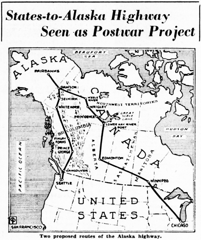
The distance by road from the United States-Canada boundary to Fairbanks, Alaska, would be about 2000 miles. Three main routes have been considered—two from Seattle through British Columbia and one from Chicago through the prairie provinces and down the Mackenzie river valley in the northwest territories. All three enter Alaska from the Yukon territory. Gravel roads on these routes now end at Hazelton, B. C., Prince George, B. C., and Grimshaw, Alta.
The Alaskan international highway commission, representing the United States, seems to favor the route from Seattle via Hazelton, and the British Columbia-Yukon-Alaska highway commission, representing Canada, the more easterly route from Prince George via Sifton pass. Either would make possible the development of mineral and timber resources in British Columbia not reached by railway or steamship lines, and would surpass the Mackenzie valley route in scenic grandeur.
Among the persons who recommend the route from Chicago via the Mackenzie valley is Vilhjalmur Stefansson, famous Arctic explorer, who recently inspected various routes.
Arctic Pipeline.
The most urgent need, however, according to Stefansson, is not several thousand miles of highway, but about 300 miles to serve as a sort of Arctic pipeline for moving oil and gasoline from a refinery at Norman to Mayo, Yukon territory, on the Alaskan side of the continental divide. This road would enter the Canadian Rockies at or north of the Keele (Gravel) river, where the mountains are much lower than in southwestern Canada.
Alaska's entire supply of oil and gasoline has to be shipped in by ocean tanker. Consideration of the long line of communication by sea, and the importance of keeping the army's big air base at Fairbanks supplied with oil and gasoline, emphasize the explorer's view.
Stefansson's findings which convinced him that the Mackenzie route was the logical one for a highway between the United States and Alaska were: 1 - It would cost the least; 2 - could be completed most quickly; 3 - would be most likely to be usable in winter; 4 - would be safest from attack; 5 - would provide a source of fuel.
Stefansson believes that it is desirable to construct highways eventually on both of the routes in British Columbia and also connecting roads from the westernmost route to cities along the coast.







